After weeks of relatively mild winter weather, a sudden and severe winter storm swept across the United States in late January 2026, catching millions off guard. Stretching from Texas through the Midwest and into New England, the sprawling system brought heavy snow, sleet, freezing rain, and dangerously cold temperatures. Governors in several states declared emergencies as travel became nearly impossible, power outages spread, and wind chills plunged to life-threatening levels expected to last for several days.
While the intensity of the cold came as a shock, scientists say the storm did not form out of nowhere. In fact, the warmer-than-average conditions earlier in the season may have helped create the perfect setup for such an extreme event. According to atmospheric and climate researchers, this storm was the result of a rare alignment of weather patterns near the surface and far above the Earth, particularly involving the jet stream and the stratospheric polar vortex.
Severe winter storms require multiple ingredients to come together at precisely the right time. One of the most important is a strong temperature contrast at the surface, where frigid Arctic air clashes with warmer air from the south. In late January, a powerful Arctic air mass surged southward, colliding with warm, moisture-laden air flowing north from the Gulf of Mexico. This sharp contrast created an ideal environment for storm development.
At the same time, the jet stream—a fast-moving river of air several miles above the Earth that steers weather systems—dipped unusually far south. Rather than a smooth west-to-east flow, the jet stream became highly wavy, allowing cold air to plunge deep into the central and eastern United States. Embedded disturbances within this distorted jet stream combined to intensify the storm and sustain it over a wide area.
Moisture played a critical role as well. The Gulf of Mexico was exceptionally warm, providing an abundant supply of water vapor to the atmosphere. As this moisture rose and condensed into rain, snow, and ice, it released energy that further strengthened the storm. This is why the system was able to produce not just snow, but also widespread freezing rain and sleet, particularly in regions where surface temperatures hovered near the freezing mark.
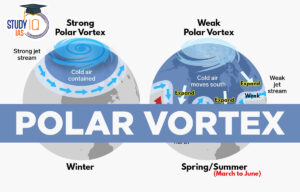
The storm’s power, however, cannot be fully understood without looking much higher into the atmosphere. More than 20 miles above the Earth’s surface, in the stratosphere, a massive circulation of cold air known as the polar vortex typically spins tightly around the North Pole. Under normal conditions, this stratospheric polar vortex remains strong and relatively stable, keeping the coldest Arctic air locked in place.
In January 2026, that stability broke down. The stratospheric polar vortex weakened and stretched southward over North America. This disruption allowed atmospheric waves to travel upward and then reflect back downward, transferring energy from the stratosphere into the troposphere, where weather occurs. When this energy returned downward, it amplified the jet stream’s north–south swings, effectively supercharging winter conditions at the surface.
Forecasts showed a rare overlap between the southward extension of the stratospheric polar vortex and the jet stream directly over the United States. This alignment created ideal conditions for Arctic air to surge southward while storm systems intensified, leading to prolonged cold, heavy precipitation, and dangerous travel conditions across much of the country.
Despite the storm’s severity, scientists emphasize that such events do not contradict the reality of climate change. The planet is undeniably warming due to human-driven greenhouse gas emissions, and average snowfall has been declining in many regions. However, warming does not eliminate winter storms; instead, it alters their character and behavior.
Research suggests that as the Arctic warms faster than the rest of the planet, the polar vortex may become more prone to disruption. When the vortex weakens or splits, cold air is more likely to escape southward into populated areas. Although these cold outbreaks may become less frequent over time, they can still be intense when they occur.
A warming climate also affects storms by increasing atmospheric moisture. Warmer oceans lead to greater evaporation, and warmer air can hold more water vapor. This additional moisture provides extra fuel for storms, allowing them to produce heavier precipitation. At the same time, warming can reduce temperature contrasts, which may weaken some storms, making it difficult to predict how average storm strength will change.
What is becoming increasingly evident is that the most extreme winter storms may be growing more intense, even as winters overall become milder. Another consequence of warming is a shift in precipitation type. Snowfall that once would have remained frozen is now more likely to fall as sleet or freezing rain, increasing the risk of ice storms that can cripple infrastructure and threaten public safety.
The January 2026 winter storm serves as a stark reminder that climate change does not simply mean less winter. Instead, it means a more volatile and unpredictable cold season, marked by sudden extremes that challenge communities, infrastructure, and emergency systems across the United States.